| Any historians and photographers of Blunn Creek?
As
part of better understanding the long-term changes in Blunn Creek, we'd like to start collecting any
old photos of the creek, or stories
about the stream. We're trying to show whether, how, at what rate, and
where the creek has been eroding. Can you please look through your old
shoeboxes of creek photos, or ask your older
neighbors, to help us understand the history of the stream's
erosion? Please send any copies of photos, or comments from SRCC-area
residents, to: David Todd, 709 East Monroe
Street, Austin, TX 78704-3131, dtodd@wt.org, 416-0400 |
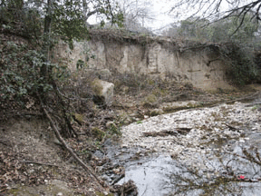
Undercut bank,
9 to 12 tall and 60 to 65 feet long, abutting East Side and west side of
Blunn Creek, in block between Woodland and East Monroe.
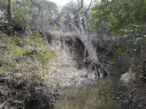
Eroded bank,
14 feet tall and 30 feet long, abutting and undercutting Sunset Road,
roughly 120 feet south of Fairmount, with 35-inch-diameter oak
lost |
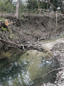
Collapsed bank, 4 to 9 feet tall by 35 feet long, on east side of
creek, roughly 50 feet south of the Woodland bridge, showing a 14-inch
juniper that has been lost in the erosion.
View these photographs at higher
resolution at Kodak Ofoto site.
View some two dozen photographs, with captions, detailing the conditions
along the course of Blunn Creek as it nears Town Lake (an Adobe Reader
*.pdf file; obtain free Adobe Reader if you don't
have it). (Photographs and captions by D.
Todd.) |
There were two walks along the northern end of Blunn Creek to take a look at erosion problems between Pecan Grove and East Live
Oak and discuss possible responses, as well as to view the
wastewater lines in the creek bed (view minutes of walks). Along for one
walk was Megan Byars, Austin Watershed Protection Division; along for the
second were Brian Noble, from the TCEQ Pollution Prevention and Business
Assistance program, and Ginny Rohlich, from the Austin Watershed
Protection Division). "In many ways, this is a continuation of the fine work
done by Karin Ascot, René Barrera, Mike Kelly, John Gleason, Ken Zarker,
Jeff Kessel, and many others who have worked in the past on trying to
stabilize the creek. All interested are invited to join one of the walks."
This information and these
photographs are by David Todd, who can provide more information if
needed. |